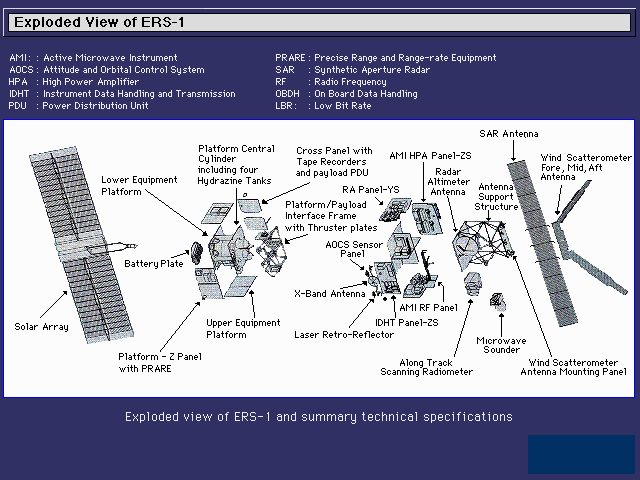
- Synthetic Aperture Radar (SAR)
- The SAR provides cloud-free radar images of mainly the Earth's surfaces, monitoring and vegatation and growth, floadings, cultivation of land. When two consecutive images are merged though the technique of interferometry (INSAR), the instrument can even detect landslides and depressions over an approximately 100x100 km area.
- Wind Scaterrometer (SCAT)
- This instrument (together with the SAR forming the Active Microwave Instrument, AMI) maps the wind speed and wind direction over ocean surfaces.
- Radar Altimeter (RA)
- The Radar Altimeter is a purely nadir looking instrument with a footprint of a few kilometers. It sends radar signals to the earth and ocean surface and collects the return pulse. The returned power as a function of travel time is called the wave form. Processing of the waveform provides information on: the wave height and wind speed (over oceans), the surface backscatter, and the height of the satellite above the surface. Together with a precisely computed orbital altitude, the latter gives the height of the surface above a well-defined geocentric reference frame. This provides the possibility to monitor the global ocean circulation, but also regional current systems, and study the marine gravity field.
- Along-Track Scanning Radiometer (ATSR)
- A sweeping mirror detects and maps infrared radiation in various wavelengths along the satellite track. When the sky is cloud-free, these measurements can be converted to land and sea surface temperature.
- Microwave Sounder
- Operating together with the ATSR, the Microwave Sounder provides a measurement of the total water vapour content in the Earth's atmosphere vertically below the satellite orbit. This measurement is essential for the correction of the RA height measurement.
- Global Ozon Monitoring Experiment (GOME)
- The GOME is a new instrument on ERS-2 that was not available on ERS-1. At is intended to map the ozon content in the upper atmosphere and provide more conclusive statistics of the development of the Ozon Hole and the effect of polution on this.
- Precise Range and Range-Rate Equipment (PRARE)
- PRARE is an active satellite tracking equipment. It sends signals to transponders positioned on Earth (currently some 20 are deployed). After reception of the return signal the relative range and range-rate (velocity) of the satellite to up to 4 transponders can be determined simultaneously. This provides a perfect means to determine the satellite position (latitude, longitude, and altitude) all around the orbit. The PRARE instrument on ERS-1 unfortunately failed soon after launch.
- Laser Retro-Reflector (LRR)
- The Laser Retro-Reflector is a purely passive ``instrument'' and can be compared to reflectors on cars and bicycles. It reflects laser pulses transmitted from Satellite Laser Ranging (SLR) systems on Earth back to the systems. The total travel time of the laser pulse (once received back by the laser system) is a direct measure for the distance between the satellite and the station. For ERS-1 this was the only means to compute a precise satellite orbit; for ERS-2 it is a helpful addition to be used in the orbit determination and for calibrating the PRARE instrument.
 |
The ERS SatellitesInstruments |
 |
The First and Second European Remote-Sensing Satellites (ERS-1 and ERS-2) are developped by the European Space Agency as a family of multi-disciplinary Earth Observation Satellites. They orbit the Earth in about 100 minutes and in 35 days have covered nearly every corner of the globe at least once. Both satellites are still in good health and provide a wealth of observations through their excellent suite of instruments:
 This page is maintained by