The Atlantic Ocean
Gravity Anomaly Maps
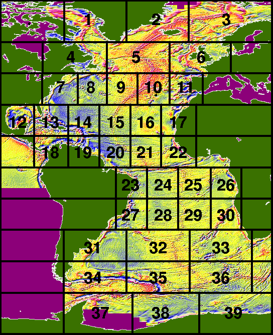
In this overview map the separate maps are shown.
The numbers correspond to the list of areas below.
Click in the overview map above or on an area name in the
index below in order to get a detailed (but
small) map of the area; large maps (1280 by 1024
pixels) are also available.
All maps overlap at least 5 degrees so the actual map
boundaries differ slightly from the boundaries in the
overview map above.
1 Greenland coast
2 Iceland
3 Norwegian Bassin
4 The Grands Banks of Newfoundland
5 Gibbs Fracture Zone
6 North Sea
7 Bermuda
8 Corner Ridge
9 Oceanographer Fracture Zone
10 Azores
11 Iberian coast
12 Gulf of Mexico
13 Bahamas
14 Puerto Rico Trench
15 Kane Fracture Zone
16 Cabe Verde Islands
17 Canary Islands
18 Colombia Bassin
19 Grenada Trough
20 St. Paul Island and Fracture Zone
21 Doldrums Fracture Zone
22 Sierra Leone Swell
23 Pernambugo Abyssal Plain
24 Ascension Island and Fracture Zone
25 Guinea Ridge
26 Congo Canyon
27 Sao Paulo Plateau
28 Rio Grande Fracture Zone
29 Angola Abyssal Plain
30 Walvis Ridge
31 Argentine Abyssal Plain
32 Tristan da Cunha
33 Cape Bassin
34 Falkland Plateau
35 Agulhas Fracture Zone
36 Bouvet Island and Fracture Zone
37 Weddell Sea
38 South Sandwich Islands
39 Dronning Maud Land
 The Altimetry Atlas opening page