Satellite Radar Altimetry
Satellite altimetry offers the possibility to measure sea surface heights
globally. Sea surface height is determined by measuring the distance
between a satellite and the sea surface using radar, after computing the
location of the satellite during the measurement and a number of
atmospheric corrections the sea surface height is known.
Satellite altimetry is used for:
- Oceanography. Since currents are detectable as slopes in the sea
surface, the worlds ocean currents can be detected and monitored.
Small scale features are visible as well, like eddies, which are
generated by the large scale currents (by the Gulf Stream, for
example). Altimeter data is also used for tide modelling.
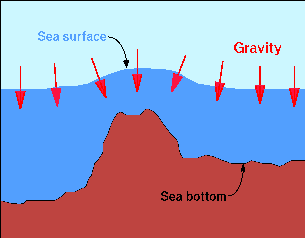
- Geophysics. Density differences in the Earths crust cause local
differences in gravity (gravity anomalies). These affect the
topography of the sea surface. The sea surface is always
perpendicular to the (local) gravity so an "mountain" in local
gravity shows up as a "hill" in the sea surface (see Figure below).
This "mountain" can be both a real subsurface seamount or island,
or it may be a local increase in density in the Earth's crust.
A accurate determination of the constant part of the sea surface
(as opposed to the time-dependant part, mostly due to oceanographic
influences) is made by averaging as much data as possible from as
many satellites as possible.
So far eight altimeters have flown on satellites. The first experiment
was flown on board SKYLAB and provided many useful engineering data on
which the following altimeters were further developped. The first scientific
altimeter mission was the one on GEOS-3. If demonstrated how flat land
and ocean surfaces could be profiled, but
lacked sufficient accuracy and coverage to do serious science.
SEASAT carried a better altimeter and offered global
coverage, unfortunately the mission failed after only some three months.
The next altimeter satellite, GEOSAT,
worked for several years. The GEOSAT data set has proven the usefullness
of the altimeter. In the 1990's already four altimeters are launched:
two identical altimeters are carried on the multi-disciplinary remote-sensing
satellites ERS-1 and ERS-2. Although ERS-1 is still in
good health, it was put into hibernation a year after its successor ERS-2
was launched and carried over its operational duties. Simultaneously,
the dedicated altimeter satellite TOPEX/POSEIDON
has been providing the most precise information to date and carries two
altimeters: a French solid-state altimeter and a US dual-frequency altimeter,
charing the time at a ratio of 1:9.
By combining the data sets of the
last four satellites a data set with an excellent coverage can be
obtained. The fact the two satellites are now carrying altimeters in orbit
simultaneously greatly improves the coverage for oceanographic studies
both temporal and spatial.
 Altimetry Atlas opening page
 This page is maintained by
Remko Scharroo,
remko.scharroo@lr.tudelft.nl
This page is maintained by
Remko Scharroo,
remko.scharroo@lr.tudelft.nl